


The Cuckfield ironworks 3/3
- gmdavison
- Mar 18, 2021
- 9 min read

Here are the locations of all the known furnaces and forges around Cuckfield village dating back to the sixteenth century . Not all the places identified on the map may be confirmed. The letters alongside the paragraphs below refer to the locations marked on the map:
A Holmsted (Gaston's Bridge) Forge, operational c1574-1664.
This was adjacent to the Ouse [TQ 2820 2740], alongside the road between Slough Green and Staplefield. It was situated on Gaston’s Farm. Its raw material in the form of ‘pig iron’ (crude iron ingots) was supplied from the Burrell’s Blackfold Furnace [TQ 2820 2740] at Handcross (referred to as ‘Tilgate’).
At Blackfold the dammed river ‘bay’ provided the motive power for the works, the location of the furnace can be seen in the valley behind the Nymans National Trust property.
A forge typically needed at least three water wheels, one each to work the bellows in the two hearths and a larger one to work the hammer - hence the term ‘hammer pond’. The river bay for Holmsted was removed in 1928 when the Slough Green to Staplefield road was realigned.
Holmsted was in business as early as 1574 when it was owned by Ninian Challoner. The Challoners were ‘of Lindfield and Cokefield’ and perhaps had a partnership with Walter Covert of Slaugham Place who owned the Slaugham Forge.
Ninian Challenor died in 1609 and we know from a will document that the forge was transferred to Ninian Burrell in 1615 but he was already running in 1605. After this there was a business partnership with John Warden of Cuckfield showing that the forge was active in 1653. We know that the site was in ruin by 1664.
The Holmsted Manor also transferred to the Burrell family, probably in 1605. Holmsted Manor was demolished in 1833 by a descendent of the Burrells - Lord Gwydyr.
Today aerial views show several ponds in the immediate area and, as the Burrells lived close by at Holmsted Manor, this suggests other production activity may have been present.
B Pilstye
This was first identified by Michael Burchall in the Summer 1973 Bulletin from the Wealden Iron Research Group. The site has not been confirmed by the experts and the evidence is largely circumstantial. It was initially found through a reference to ‘furnace’ in a will. But subsequently Cuckfield Connections has identified that one of the Challenor ironmaster family, Richard Challenor, lived at the nearby Upper Pilstye and, coupled with the age of the house and its position alongside the River Ouse, plus its inclusion in a canal proposal - makes this a very plausible location.
So where is Pilstye? Head to the end of Brook Street, just over two miles north of the centre of Cuckfield take the fork left onto Rowhill Lane. ‘Upper Pilstye’ is a short distance to the west of the Balcombe Road [TQ304285]. The 'Pilstye' name has Saxon origins and means ‘pond in a field’. On the Tithe Map the area is shown as ‘Pit Field’ and amounts to some six acres. It includes a pond - although this had gone by 1874.
John Jenner, who died in 1688, wrote in his will in 1683, 'unto my said Sonne Ambrose, Jenner the Plate and Two cast Andirons standing in the Kitchen … And the furnace there at Pilsty.’ But this could also refer to a kitchen oven rather than an iron furnace.
Although a very likely location for a water-powered mill, with a pond and the River Ouse to feed it, we need to be cautious as the word ‘furnace’ could refer to an oven used for domestic cooking.
But one of the occupants Richard, was the son of Ninian Challoner who ran Holmsted Forge. But we have no written record that Richard was directly involved with ironmaking, but this seems highly likely.
We know through parish records of a burial and a baptism that, Richard was living at the Pilstye property 1605-1607, although it could be longer. We know he then he moved to Barnsnape in Broxmead Lane and was certainly there by 1618, the house was previously occupied by his uncle John Challenor who died in 1607.
The Challoner family also hailed from Lindfield and the main family home was Kenwards one mile NW of Lindfield, about five miles from Pilstye.
It would appear that Pilstye was a bigger settlement than it is today, and we know that it dates back to the 1250s. So why was it larger? Could iron production have been the reason?
Then there are the two fine period buildings of an appropriate period - but then they may just have been farmsteads.
Another clue that might substantiate the Pilstye location is that, although never completed, there was a proposal for a canal link to the Ouse between [where I = ironworks location] Slaugham (I), Holmsted (I), Pilstye (I?) then onto Haywards Heath, Lindfield (I) the Lewes and the English Channel. It was completed up to where the Balcombe viaduct is today in 1812 but the project was never completed.
The presence of the canal could add credibility to the idea that there were iron-workings at Pilstye. But perhaps it was simply where the canal would have joined up with the River Ouse. A canal lock might have been necessary and perhaps a turning point, and Pilstye just happened to be there - and that there is no connection with ironworks at that location.
C Cuckfield Furnace This is the best known of Cuckfield’s ironwork sites and, because of its remote location, it still survives - although little remains other than earthworks. It’s located south of Mackrell’s Farm [TQ 3037 2300]. These ironworks were in use at least between 1583 and 1613. Our previous article covered this location in depth.
D Cuckfield Forge
This is 200m north of Cuckfield Furnace on a part of the Ouse [TQ 3025 2354] associated with the Cuckfield Swimming ‘Baths’ that opened in 1905. Again there is more on this in our previous article.
E Highbridge Mill TQ 2960 2370
The mill building we see today was a flour grinding mill dating from 1810, but this is located on the former site of an ironworks. WIRG did a site visit in 1979 and Fred Tebbutt (WIRG’s first Chairman) reported that slag was found on a ‘field surface near Highbridge Mill’.
Herbert Bates recorded in his diary when the flour mill opened for business on 24 June 1811: ‘Mr Jacob Caffyn’s new mill set a going at 5 o’clock afternoon, This water mill on the south side of the present A272 road [at Highbridge] was in competition with the old mill on the north side owned by the Sergison family and some years later Colonel Sergison's sister, Miss Prichard Sergison, attempted to ruin Mr Caffyn by cutting off the water supply to his mill.’ The present watermill closed for business around 1930.
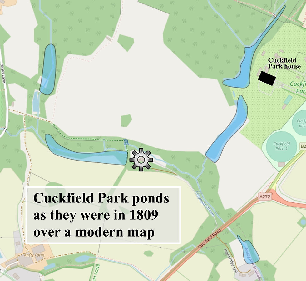
F and G Cuckfield Park There is now evidence to substantiate at least one ironworks on the stream system within the boundaries of Cuckfield Park. From the 1809 Sergison Estate map, we know that there were four large dammed ponds. It's very possible that at some time one - or even all - may have been used to service ironworks. They were all vey close to the ironmaster’s manor house after all.
The upstream ponds may have been ‘pen ponds’ acting as a reservoir to give extra water capacity and working time for driving equipment driven by the downstream pond.
In an earlier article we published Saunterer from Mid Sussex Times gave us useful confirmation that there was an iron furnace below the two western lakes, and that a corn mill subsequently replaced it.
The two ponds adjacent to the Cuckfield Park mansion may simply have been ornamental. After all, why would the ironmaster want the noise of hammering to interfere with his domestic life? But if business demand was high - such as at a time of war - then the ironmaster could bring production capacity onstream.
By way of confirmation, a villager did pass on a story from his father - that could date to around the turn of the 19/20th centuries - that there had been an ironworks between the two ponds closest to the house.
Fieldwork in this area conducted by WIRG many years ago proved inconclusive, due to the thick undergrowth present at the time.
H and I ‘West Street’ locations not on the map
These potential locations have been identified exclusively by Cuckfield Connections.
H to the east of the sharp bend in Broxmead Lane [TQ 2830 2420]
I near where Pickwell Lane and Broxmead Lane meet [TQ 2770 2420]
There may have been one or even two works powered by the same water course that becomes the River Adur passing through Cuckfield Park. There would have been a service road connecting Broxmead Lane and Deaks Lane and, from there, another links through to Cuckfield Park.
There is coppiced woodland in the area, which might have served them.

Deak’s Lane, Broxmead Lane and Pickwell Lane are all ancient north-south droveways linking the wooded Wealden pastures to the old estates at the foot of the South Downs, reputedly they were also a convenient parallel road for smugglers moving their contraband north. Oxen were used to move materials iron for ironworks - and such secondary routes meant they wouldn’t obstruct and churn up the main coach routes.
The Saunterer, in the article mentioned above, refers to the forest clearance in this area and 'the sturdy race of yeomen who cleared the great forest of the immense timber trees that covered it'.
There was a remote settlement called West Street which is marked on early OS maps up to the end of the 19th century (eg the one from 1879) and it’s adjacent to site ‘H’. What did this hamlet serve? These ironworks may be the answer.
Westup and the Ives family
No longer existing is Westup a fine Elizabethan house owned by the Ives family. It is believed to have been mid-way between Deaks Lane and Broxmead Lane. A photo exists in Cuckfield Museum of a beautiful wooden 'dog gate' at Westup. Little is known about the Ives but the Saunterer writes that they 'must have been of considerable importance in the parish' as they had a 'vault in the interior of [Cuckfield] Church'. Henry and Thomas Ives are listed as Trustees to Cuckfield Grammar School in 1641.
Rev James Hughes Cooper in 'History of Cuckfield' [P82] lists 'Henerie Ive of Westup' as a landowner in 1679 on a map of 'the Manor of Cockfield' and [on P107] in 1707 Henry and Thomas Ives were listed as being present at a Christmas Dinner as principal yeoman of Cuckfield.

There is another period manor house close by, built in the 17th century. It's four hundred yards north if West Street in Broxmead Lane and called Barnsnape, which is still there today. John Challenor of the ironmaster dynasty lived there until he died in 1618 and it was then occupied by his son Richard moved from Pilstye, and in turn on his death in 1630 his son, also called Richard, lived there.
As Richard Snr was not in charge of Holmsted works - this suggests - and perhaps supported by the fact that Barnsnape was so far from Holmsted Forge - that he was engaged in iron workings that were located closer at hand.
With the tributary for the Adur running yards to the South with sufficient flow to power the furnace below - as supporting a 'now lost' village for workers, the presence of two fine Elizabethan properties all adds circumstantial evidence that there may have been further iron workings to the North West of Cuckfield. Clearly there is potential for future site research.
In conclusion
It is impressive just how much we do know about the iron industry of the Weald. This despite the loss of so many of the written records in the intervening 400 or more years. But the patchy nature of Cuckfield's written record is frustrating. It appears that Cuckfield Connections has identified at least three extra sites of iron workings in the village that we were previously unaware of. Now, with the landowners help, it would great if we were able to check them out.
To take this study further, to understand the true scale, establish the products that were made, locate lost works from this very significant local industry we need all the input we can get. Please do get in touch if you can offer any information to Cuckfield Connections that you think might be of value.
Sources
A big thank you to Tim Smith, Honorary Secretary of the Wealden Iron Research Group that has been carrying out rigorous research on this subject for over 50 years. www.wealdeniron.org.uk.
Saunterer II, Mid Sussex Times, 23 August 1887, 'Saunterer's observations on Deaks Lane' [Cuckfield Connections article]
‘The Iron Industry of the Weald’, by Henry Cleare and David Crossley, 1995, Merton Priory Press.
‘The Wealden Iron Industry’, by Jeremy Hodgkinson, 2009. The History Press.
‘Wealden Iron’, Ernest Straker, 1931, G Bell.
‘A Chronicle of Cuckfield’ by Maisie Wright, 1991.
‘A History of Cuckfield’, Rev. Canon JH Cooper, Charles Clarke, 1912.
‘Pyecombe to Cuckfield, With Stops Along the Way’, Mark Dudeney and Eileen Hallett, 1999, Mid Sussex Books.
‘Sussex in the Great Civil War and the interregnum 1642-1660’, pub 1910, Chiswick Press.
Cuckfield Grammar School and National School, reference to Ives family in the National Archives.
Map data with open database licence from openstreetmap.org. Copyright link. https://www.openstreetmap.org/copyright
Cuckfield Park pond locations are based on the Sergison Estate map which is viewable at the West Sussex County Archive.
The Sussex Oxen photograph is a postcard from the early 20th century.
The Burrell portrait was published by Michelle Hooper on ancestry.com.
Contributed by Malcolm Davison.
Comentarios